Image:Beaverriverpamap.png
Un article de Wikipédia, l'encyclopédie libre.
Pas de plus haute résolution disponible.
Beaverriverpamap.png (500 × 500 pixels, taille du fichier : 98 Kio, type MIME : image/png)
| | Ce fichier provient de Wikimedia Commons?. Les informations le concernant sont affichées ci-dessous (procédure). |
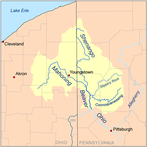
| Description |
Map of the Beaver River watershed. |
|---|---|
| Source |
Self-made, based on USGS data. |
| Date |
May 22, 2008 |
| Author | |
| Permission (Reusing this image) |
see below |
|
Historique du fichier
Cliquer sur une date et une heure pour voir le fichier tel qu’il était à ce moment-là
| Date et heure | Dimensions | Utilisateur | Commentaire | |
|---|---|---|---|---|
| actuel | 22 mai 2008 à 20:33 | 500×500 (98 Kio) | Kmusser | ({{Information |Description=Map of the Beaver River watershed. |Source=Self-made, based on USGS data. |Date=May 22, 2008 |Author= Kmusser }} {{self|cc-by-sa-3.0}} [[Category:Maps of rivers) |
Pages contenant l’image
La page ci-dessous contient cette image :

