Image:Bay Bridge collapse.jpg
Un article de Wikipédia, l'encyclopédie libre.
Pas de plus haute résolution disponible.
Bay_Bridge_collapse.jpg (341 × 512 pixels, taille du fichier : 21 Kio, type MIME : image/jpeg)
| | Ce fichier provient de Wikimedia Commons?. Les informations le concernant sont affichées ci-dessous (procédure). |
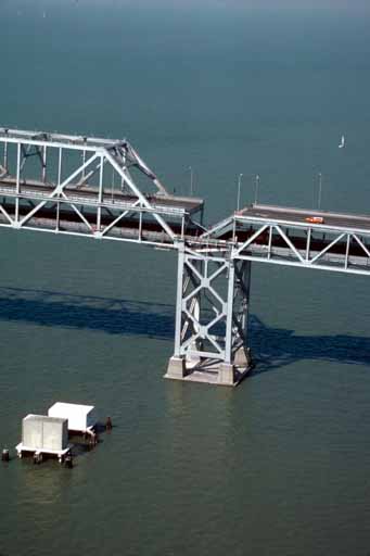
USGS photo from 1989 Loma Prieta earthquake.
Caption: Aerial view of roadbed collapse near the interface of the cantil�T truss sections of the San Francisco-Oakland Bay Bridge. View northwestward. [C.E. Meyer, U.S. Geological Survey]
Original image here: http://wrgis.wr.usgs.gov/dds/dds-29/web_pages/bay_bridge.html, now at http://pubs.usgs.gov/dds/dds-29/web_pages/bay_bridge.html
| This image is in the public domain because it contains materials that originally came from the United States Geological Survey, an agency of the United States Department of Interior. For more information, see the official USGS copyright policy |
|
Historique du fichier
Cliquer sur une date et une heure pour voir le fichier tel qu’il était à ce moment-là
| Date et heure | Dimensions | Utilisateur | Commentaire | |
|---|---|---|---|---|
| actuel | 21 septembre 2005 à 23:17 | 341×512 (21 Kio) | Wolfgang K | ( [http://wrgis.wr.usgs.gov/dds/dds-29/ USGS photo] from 1989 Loma Prieta earthquake. '''Caption''': Aerial view of roadbed collapse near the interface of the cantil�T truss sections of the San Francisco-Oakland Bay Bridge. View northwestward. [C.) |
Pages contenant l’image
Les pages ci-dessous contiennent cette image :

