Image:Aranislandssatmap.jpg
Un article de Wikipédia, l'encyclopédie libre.
Pas de plus haute résolution disponible.
Aranislandssatmap.jpg (555 × 352 pixels, taille du fichier : 115 Kio, type MIME : image/jpeg)
| | Ce fichier provient de Wikimedia Commons?. Les informations le concernant sont affichées ci-dessous (procédure). |
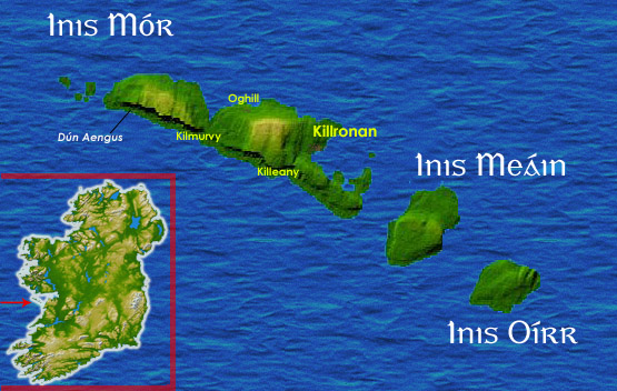
Aran Islands map from sat. Personal image amended from sat page here
Author Kanchelskis.

 |
This map image should be recreated using vector graphics as an SVG file. This has several advantages; see Commons:Media for cleanup for more information. If an SVG form of this image is already available, please upload it. After uploading an SVG, replace this template with template {{Vector version available|new image name.svg}} in this image. |
|
العربية | Български | Català | Česky | Dansk | Deutsch | English | Esperanto | Español | Français | 한국어 | Italiano | Magyar | Lietuvių | Nederlands | 日本語 | Polski | Português | Română | Русский | Suomi | Svenska | Türkçe | Українська | Tiếng Việt | मराठी | 中文(繁體) | 中文(简体) | +/- |
|
Historique du fichier
Cliquer sur une date et une heure pour voir le fichier tel qu’il était à ce moment-là
| Date et heure | Dimensions | Utilisateur | Commentaire | |
|---|---|---|---|---|
| actuel | 27 juin 2005 à 12:39 | 555×352 (115 Kio) | Kanchelskis | (better version) |
| 27 juin 2005 à 10:02 | 555×352 (116 Kio) | Kanchelskis | (Aran Islands map from sat. Personal image amended from sat page [http://commons.wikimedia.org/wiki/Image:Topography_Ireland.jpg here] Author Kanchelskis. {{GFDL}}) |
Pages contenant l’image
Les pages ci-dessous contiennent cette image :
Métadonnées
Ce fichier contient des informations supplémentaires probablement ajoutées par l’appareil photo numérique ou le numériseur qui l’a acquis. Si le fichier a été modifié depuis son état original, certains détails peuvent ne pas refléter entièrement l’image modifiée.
| Orientation | Normale |
|---|---|
| Résolution horizontale | 72 dpi |
| Résolution verticale | 72 dpi |
| Logiciel utilisé | Adobe Photoshop CS Windows |
| Date de modification | 27 juin 2005 à 12:38 |
| Espace colorimétrique | 65535 |

