Image:Appalachian map.jpg
Un article de Wikipédia, l'encyclopédie libre.
Taille de cet aperçu : 422 × 599 pixels
Image en plus haute résolution (432 × 613 pixels, taille du fichier : 55 Kio, type MIME : image/jpeg)
| | Ce fichier provient de Wikimedia Commons?. Les informations le concernant sont affichées ci-dessous (procédure). |
La bildo estas kopiita de wikipedia:en. La originala priskribo estas:
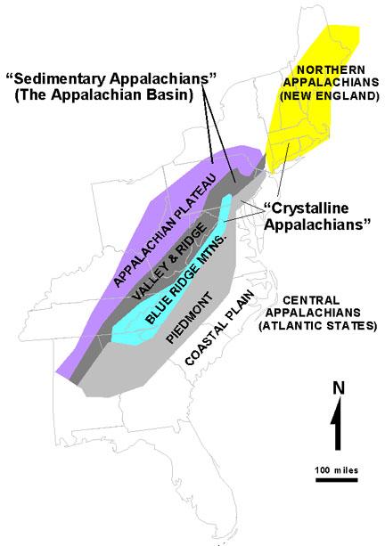
The Appalachians - USGS
http://3dparks.wr.usgs.gov/nyc/images/fig51.jpg also http://3dparks.wr.usgs.gov/nyc/common/captions.htm
| This image is in the public domain because it contains materials that originally came from the United States Geological Survey, an agency of the United States Department of Interior. For more information, see the official USGS copyright policy |
|
| date/time | username | edit summary |
|---|---|---|
| 02:53, 8 August 2005 | en:User:Vsmith | (The Appalachians - USGS http://3dparks.wr.usgs.gov/nyc/images/fig51.jpg also http://3dparks.wr.usgs.gov/nyc/common/captions.htm {{PD-USGov-Interior-USGS}}) |
[edit] Historio de la dosiero
Legend: (cur) = this is the current file, (del) = delete this old version, (rev) = revert to this old version.
Click on date to download the file or see the image uploaded on that date.
- (del) (cur) 02:53, 8 August 2005 . . en:User:Vsmith Vsmith ( en:User_talk:Vsmith Talk) . . 432x613 (56702 bytes) (The Appalachians - USGS http://3dparks.wr.usgs.gov/nyc/images/fig51.jpg also http://3dparks.wr.usgs.gov/nyc/common/captions.htm { { PD-USGov-Interior-USGS } })
Historique du fichier
Cliquer sur une date et une heure pour voir le fichier tel qu’il était à ce moment-là
| Date et heure | Dimensions | Utilisateur | Commentaire | |
|---|---|---|---|---|
| actuel | 5 février 2006 à 20:46 | 432×613 (55 Kio) | Maksim | (La bildo estas kopiita de wikipedia:en. La originala priskribo estas: The Appalachians - USGS http://3dparks.wr.usgs.gov/nyc/images/fig51.jpg also http://3dparks.wr.usgs.gov/nyc/common/captions.htm {{PD-USGov-Interior-USGS}} {| border="1" ! date/time ) |
Pages contenant l’image
Les pages ci-dessous contiennent cette image :

