Image:Aitken clem big.gif
Un article de Wikipédia, l'encyclopédie libre.
Taille de cet aperçu : 600 × 600 pixels
Image en plus haute résolution (622 × 622 pixels, taille du fichier : 162 Kio, type MIME : image/gif)
| | Ce fichier provient de Wikimedia Commons?. Les informations le concernant sont affichées ci-dessous (procédure). |
| Description |
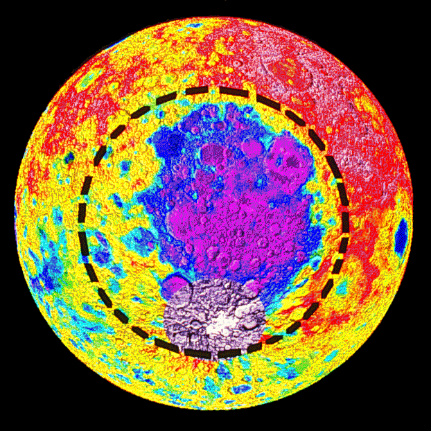
This image is an elevation map of the South Pole-Aitken basin on the Moon, derived from data collected by the NASA/SDIO probe Clementine. [1] establishes that the colors represent elevations, but unfortunately the resolution is too low for me to make out what numbers go with what hues. |
|---|---|
| Source | |
| Date | |
| Author |
Clementine Project |
| Permission (Reusing this image) |
see below |
|
|
This file is in the public domain because it was created by NASA. NASA copyright policy states that "NASA material is not protected by copyright unless noted". (NASA copyright policy page or JPL Image Use Policy).
Deutsch | English | Español | Français | Nederlands | Português | Русский | 中文(简体) | 中文(繁體) | +/- |
|
 |
Warnings:
|
Historique du fichier
Cliquer sur une date et une heure pour voir le fichier tel qu’il était à ce moment-là
| Date et heure | Dimensions | Utilisateur | Commentaire | |
|---|---|---|---|---|
| actuel | 21 mai 2006 à 20:55 | 622×622 (162 Kio) | Bryan Derksen | (Cropping and removing dither fuzz from the black background areas to reduce file size.) |
| 21 mai 2006 à 20:40 | 800×622 (283 Kio) | Bryan Derksen | ({{Information| |Description=This image is an elevation map of the en:South Pole-Aitken basin on the Moon, derived from data collected by the NASA/SDIO probe en:Clementine (probe). [http://solarsystem.nasa.gov/multimedia/gallery/Aiken_Maps.jpg] est) |
Pages contenant l’image
Les pages ci-dessous contiennent cette image :


![[1]](http://solarsystem.nasa.gov/multimedia/gallery/Aiken_Maps.jpg)