Image:1984 fictious world map v2 arr.png
Un article de Wikipédia, l'encyclopédie libre.
Taille de cet aperçu : 800 × 406 pixels
Image en plus haute résolution (1 200 × 609 pixels, taille du fichier : 235 Kio, type MIME : image/png)
| | Ce fichier provient de Wikimedia Commons?. Les informations le concernant sont affichées ci-dessous (procédure). |
[edit] Summary
| Description |
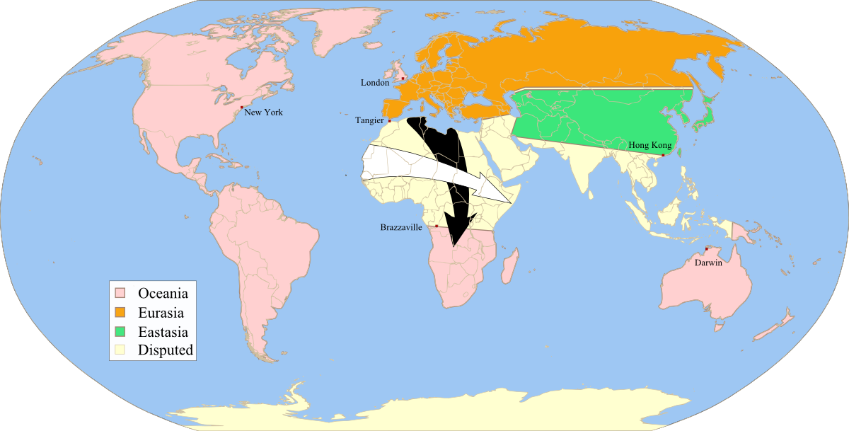
Fictitious map, illustrating the political landscape of Orwell's Nineteen-Eighty-four,approximate map of the "Black arrows" and "white arrows" described at the end of the book, rendered from Image:1984_fictious_world_map_v2.svg, inspired by Image:1984_fictious_world_map.png and Image:1984_Orwell_arrows_2.png, based on Image:BlankMap-World6.svg, created following Wikipedia's map color standard. |
||
|---|---|---|---|
| Source |
self-made |
||
| Date |
14.01.2008 |
||
| Author | |||
| Permission (Reusing this image) |
|
 |
This map image should be recreated using vector graphics as an SVG file. This has several advantages; see Commons:Media for cleanup for more information. If an SVG form of this image is already available, please upload it. After uploading an SVG, replace this template with template {{Vector version available|new image name.svg}} in this image. |
|
العربية | Български | Català | Česky | Dansk | Deutsch | English | Esperanto | Español | Français | 한국어 | Italiano | Magyar | Lietuvių | Nederlands | 日本語 | Polski | Português | Română | Русский | Suomi | Svenska | Türkçe | Українська | Tiếng Việt | मराठी | 中文(繁體) | 中文(简体) | +/- |
|
[edit] Licensing
| I, the copyright holder of this work, hereby release it into the public domain. This applies worldwide. In case this is not legally possible: Afrikaans | Alemannisch | Aragonés | العربية | Asturianu | Български | Català | Česky | Cymraeg | Dansk | Deutsch | Eʋegbe | Ελληνικά | English | Español | Esperanto | Euskara | Estremeñu | فارسی | Français | Galego | 한국어 | हिन्दी | Hrvatski | Ido | Bahasa Indonesia | Íslenska | Italiano | עברית | Kurdî / كوردی | Latina | Lietuvių | Latviešu | Magyar | Македонски | Bahasa Melayu | Nederlands | Norsk (bokmål) | Norsk (nynorsk) | 日本語 | Polski | Português | Ripoarisch | Română | Русский | Shqip | Slovenčina | Slovenščina | Српски / Srpski | Svenska | ไทย | Tagalog | Türkçe | Українська | Tiếng Việt | Walon | 中文(简体) | 中文(繁體) | zh-yue-hant | +/- |
Historique du fichier
Cliquer sur une date et une heure pour voir le fichier tel qu’il était à ce moment-là
| Date et heure | Dimensions | Utilisateur | Commentaire | |
|---|---|---|---|---|
| actuel | 14 janvier 2008 à 22:58 | 1 200×609 (235 Kio) | Twisp | (== Summary == {{Information |Description=Fictitious map, illustrating the political landscape of Orwell's [http://en.wikipedia.org/wiki/Nineteen_Eighty-Four Nineteen-Eighty-four],approximate map of the "Black arrows" and "white arrows" described at the en) |
Pages contenant l’image
La page ci-dessous contient cette image :

