Image:US landings.jpg
Un article de Wikipédia, l'encyclopédie libre.
Taille de cet aperçu : 800 × 545 pixels
Image en plus haute résolution (2 000 × 1 363 pixels, taille du fichier : 437 Kio, type MIME : image/jpeg)
| | Ce fichier provient de Wikimedia Commons?. Les informations le concernant sont affichées ci-dessous (procédure). |
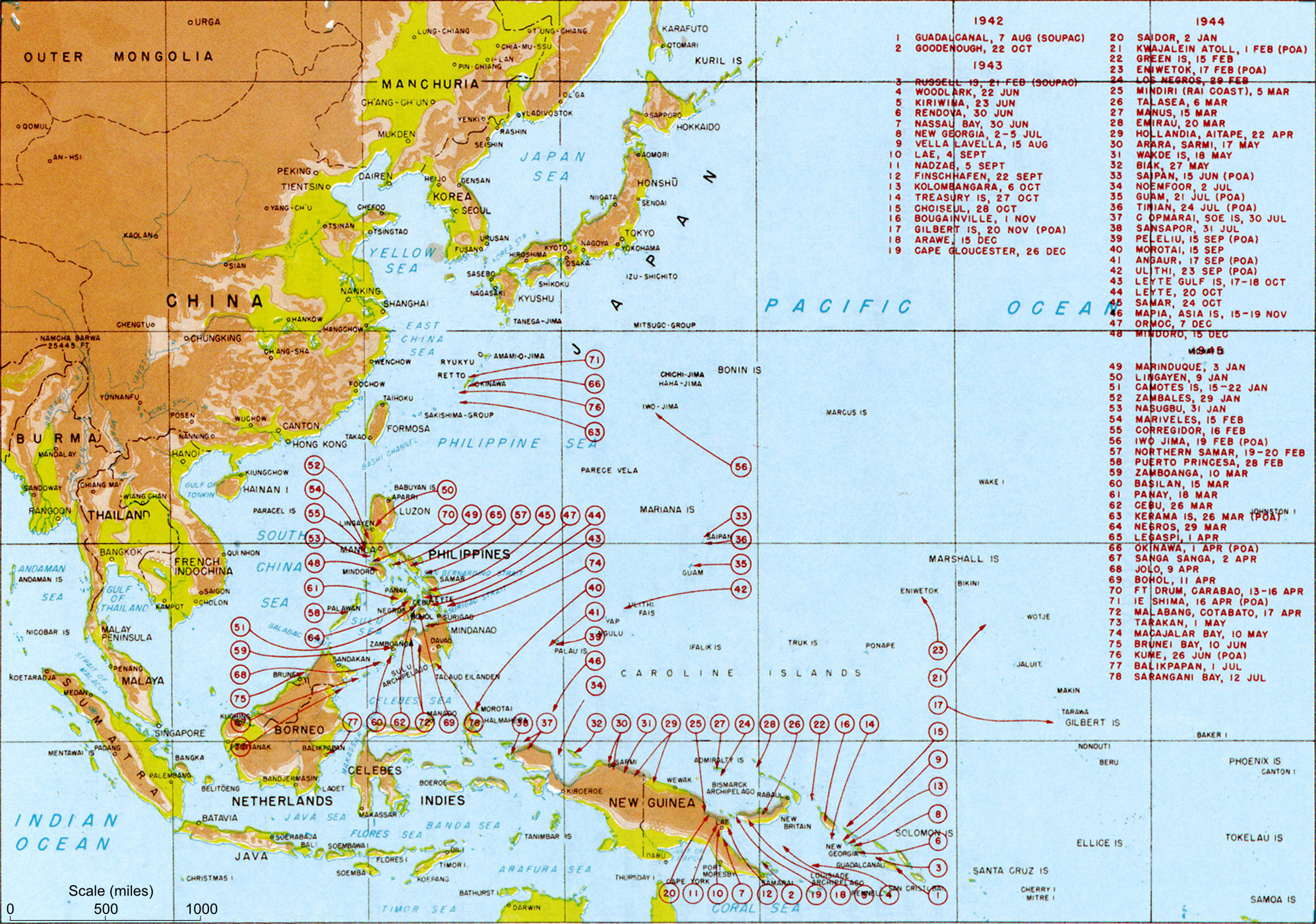
Allied landings - August 1942 to August 1945
Source: Scanned from Reports of General MacArthur (1994 facsimile printing), Vol 1. Plate #126 License: Official US government document - believed public domain.
It should be noted that while the title of the image is "US Landings" the map also indicates the position of many landings by Australian troops (at least) so should be referred to as "Allied landings".
| This image is a work of a U.S. military or Department of Defense employee, taken or made during the course of an employee's official duties. As a work of the U.S. federal government, the image is in the public domain. See the DoD copyright policy. |
 |
xfer from WP Image of same name. Text above copied from WP. perfomred by Mak 21:58, 29 May 2006 (UTC)
Historique du fichier
Cliquer sur une date et une heure pour voir le fichier tel qu’il était à ce moment-là
| Date et heure | Dimensions | Utilisateur | Commentaire | |
|---|---|---|---|---|
| actuel | 29 mai 2006 à 23:58 | 2 000×1 363 (437 Kio) | Makthorpe | (Allied landings - August 1942 to August 1945 Source: Scanned from Reports of General MacArthur (1994 facsimile printing), Vol 1. Plate #126 Category:World War II (pacific) Category: WWII maps (Pacific) License: Official US government document -) |
Pages contenant l’image
Les pages ci-dessous contiennent cette image :
- Seconde Guerre mondiale
- Projet:Histoire militaire/Seconde Guerre mondiale
- Discuter:Campagnes du Pacifique
- Discussion Projet:Histoire militaire/Seconde Guerre mondiale
- Discussion Utilisateur:Archeos/Discussions de salle de rédaction
- Discussion Utilisateur:L'amateur d'aéroplanes
- Discussion Projet:Histoire militaire/Seconde Guerre mondiale/Salle d'opérations
- Discussion Utilisateur:Lilliputien/Renseignements généraux/RAZ
- Discussion Projet:Histoire militaire/Archives 2006
- Utilisateur:Pontauxchats/Archives Pontauxchats 9
Métadonnées
Ce fichier contient des informations supplémentaires probablement ajoutées par l’appareil photo numérique ou le numériseur qui l’a acquis. Si le fichier a été modifié depuis son état original, certains détails peuvent ne pas refléter entièrement l’image modifiée.
| Orientation | Normale |
|---|---|
| Résolution horizontale | 300 dpi |
| Résolution verticale | 300 dpi |
| Logiciel utilisé | ACD Systems Digital Imaging |
| Date de modification | 25 novembre 2005 à 16:08 |
| Positionnement YCbCr | 1 |
| Version EXIF | 2.2 |
| Date de modification | 531 |
| Espace colorimétrique | 65535 |

