Image:Papua New Guinea map.png
Un article de Wikipédia, l'encyclopédie libre.
Pas de plus haute résolution disponible.
Papua_New_Guinea_map.png (330 × 355 pixels, taille du fichier : 10 Kio, type MIME : image/png)
| | Ce fichier provient de Wikimedia Commons?. Les informations le concernant sont affichées ci-dessous (procédure). |
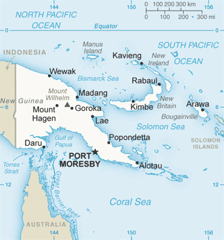
Map of Papua New Guinea from CIA world fact book
| This image is in the public domain because it contains materials that originally came from the United States Central Intelligence Agency's World Factbook.
Deutsch | English | Español | Français | 日本語 | Nederlands | 한국어 | Português | தமிழ் | Magyar | +/- |
 |
Historique du fichier
Cliquer sur une date et une heure pour voir le fichier tel qu’il était à ce moment-là
| Date et heure | Dimensions | Utilisateur | Commentaire | |
|---|---|---|---|---|
| actuel | 27 décembre 2005 à 11:29 | 330×355 (10 Kio) | *drew | (Map of Papua New Guinea from CIA world fact book {{PD-USGov-CIA-WF}} Category:Maps of Papua New Guinea) |
Pages contenant l’image
Les pages ci-dessous contiennent cette image :

