Image:Internet map 1024.jpg
Un article de Wikipédia, l'encyclopédie libre.
Taille de cet aperçu : 600 × 600 pixels
Image en plus haute résolution (1 280 × 1 280 pixels, taille du fichier : 1,27 Mio, type MIME : image/jpeg)
| | Ce fichier provient de Wikimedia Commons?. Les informations le concernant sont affichées ci-dessous (procédure). |
This is a featured picture on English Wikipedia and is considered one of the finest images.
|
This image was copied from wikipedia:en. The original description was: Image:Internet map 1024.jpg
[edit] Summary
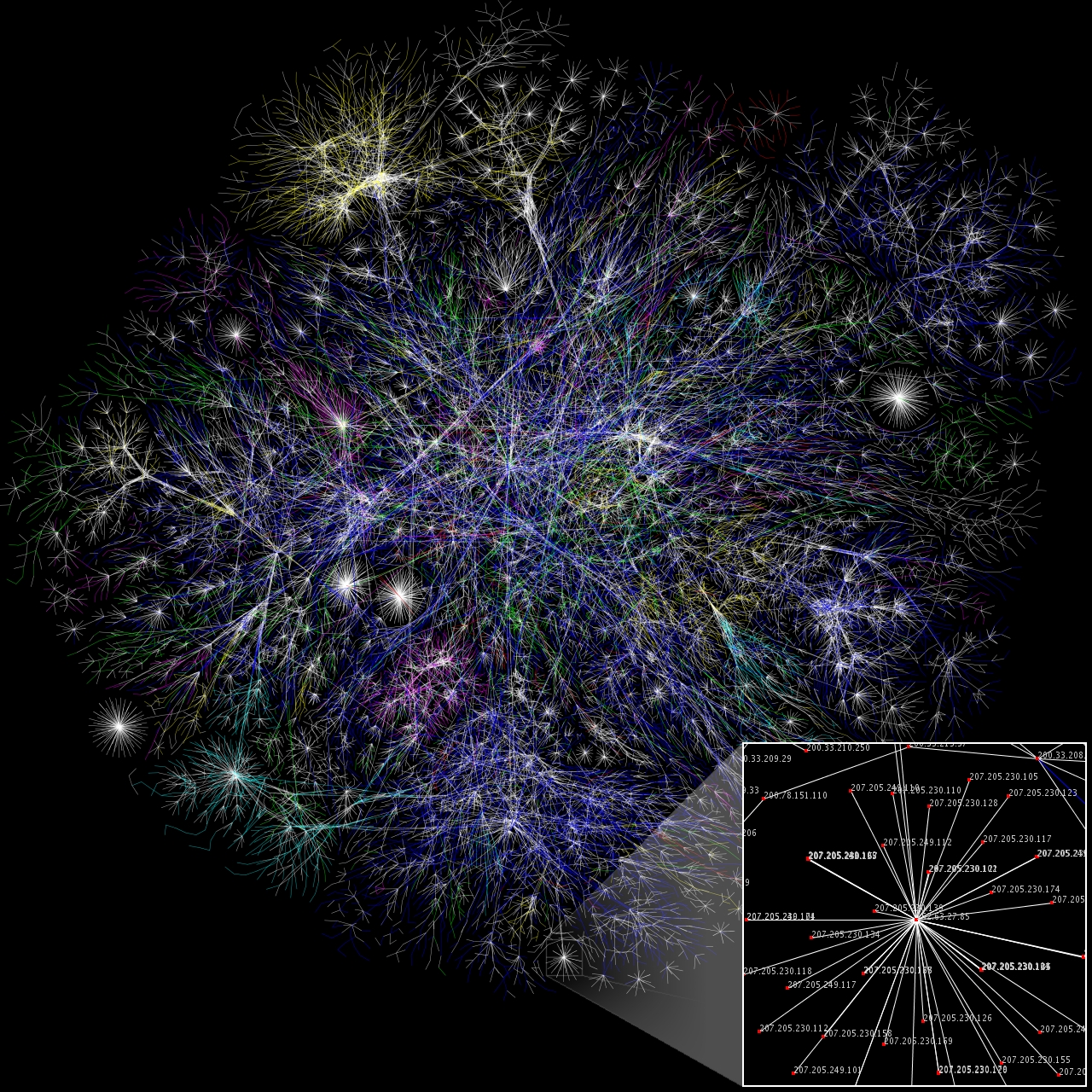
I created this small partial map of the Internet from the 2005-01-15 data found here using a slightly different rendering technique than was used to generate the maps there. Each line is drawn between two nodes, representing two IP addresses. The length of the lines are indicative of the delay between those two nodes. This graph represents less than 30% of the Class C networks reachable by the data collection program in early 2005. Lines are color-coded according to their corresponding RFC 1918 allocation as follows:
- Dark blue: net, ca, us
- Green: com, org
- Red: mil, gov, edu
- Yellow: jp, cn, tw, au, de
- Magenta: uk, it, pl, fr
- Gold: br, kr, nl
- White: unknown
Big BIG HUGE (probably unusable in articles) version can be found at [1].
- Тёмно-синий: net, ca, us
- Зелёный: com, org
- Красный: mil, gov, edu
- Жёлтый: jp, cn, tw, au, de
- Розовый: uk, it, pl, fr
- Сине-зелёный: br, kr, nl
- Белый: не определено
[edit] Licensing
| This file is licensed under Creative Commons Attribution 2.5 License In short: you are free to distribute and modify the file as long as you attribute its author(s) or licensor(s). |
| date/time | username | resolution | size | edit summary |
|---|---|---|---|---|
| 17:00, 1 December 2006 | Matt Britt | 1280×1280 | 1,328,218 | (Slightly fixed small box location.) |
| 16:48, 1 December 2006 | Matt Britt | 1280×1280 | 1,328,454 | (Newer version, higher res.) |
| 05:29, 3 November 2006 | Matt Britt | 1024×1024 | 522,255 | (== Summary == I created this small partial map of the Internet from the <a href="/w/index.php?title=2005-01-15&action=edit" class="new" title="2005-01-15">2005-01-15</a> data found [http://www.opte.org/maps/ here] using a slightly different rendering technique than was used to generate the maps there. Each line is drawn between two nod) |
Historique du fichier
Cliquer sur une date et une heure pour voir le fichier tel qu’il était à ce moment-là
| Date et heure | Dimensions | Utilisateur | Commentaire | |
|---|---|---|---|---|
| actuel | 7 janvier 2007 à 17:51 | 1 280×1 280 (1,27 Mio) | Dodek | (This image was copied from wikipedia:en. The original description was: {{FeaturedPicture|Internet Map}} == Summary == I created this small partial map of the Internet from the 2005-01-15 data found [http://www.opte.org/maps/ here] using a slightly d) |
Pages contenant l’image
Les pages ci-dessous contiennent cette image :


![[1]](http://en.wikipedia.org/wiki/Image:Internet_map_4096.png)